kaspar-sickermann
in kaspar-sickermann.de
TH Land und Leute

This and That about Thailand

Khao Sam Roi Yot National Park

NOV 2014

red bar
home
dies und das in... kaspar-sickermann.de
Übersicht / sitemap
Impressum / legal notice
mail-Adresse
red bar
home → Start "this and that" → Thailand (overview) → Khao Sam Roi Yot
© W. Kaspar-Sickermann
Khao Sam Roi Yot  -  Tham Phraya Nakon  -  Lotus Marsh  -  Shrimp-Harvest  -  Khao Daeng
small red line

Click the images! Nearly all of them have a blow up

Sam Roi Yot
map Sam Roi Yot

Mountains of Three Hundred Peaks

… that is the translation of "Khao Sam Roi Yot".

These mountains at the seacoast are situated in the province of Prachuap Khirikan. Steep slopes, peaks up to 600 m, caves, beaches and marsh in an area of about 99 km2.

It was here that King Mongkut, Rama IV, observed with guests a total eclipse, which he himself had exactly calculated. This excursion had bad consequences for him. He was infected by malaria and died two months later.

The Sala (pavillon) Kuha Karuhas in Tham (cave) Phraya Nakhon was erected in 1890 in honour of king Chulalongkorn (Rama V), when he visited the site.

In defiance of the National Park regulations shrimp farms destroy more and more the large marshes.

Sam Roi Yot, view from the North
approach from the North
Sam Roi Yot, view from the West
Sam Roi Yot, view from highway 4 in the West

For many years I came to this place ever and ever again. The sea, rocks, caves and marshes are really impressing. You are invited to accompany me

Sam Roi Yot, limestone
I think, that I know him!
top
small red line
Sam Roi Yot, Relief Kuha Karuhas Pavilion
This relief of the
Kuha Karuhas Sala
(pavilion) is situated
in Ban (village) Bang Pu Sai.
It is guarded by
lobsters and sea snakes.
Our excursion starts from this place.
[click the image !]

Tham (cave) Praya Nakhon [2012]

At first: The cave consists of two chambers
Next: Both chambers are sinkholes

Did you click on the relief  ??!!
There is no direct access from the road. A cape separates Ban Bang Pu Sai and the beach, from where you start to the cave. You have to rent a boat or you have to traverse the cape on foot.

Behind the cape we arrive at the beach. From there we have to mount onto a sharp ascent. From the crest we follow the downward path into the first chamber.

Sam Roi Yot, boats at Ban Bang Pu Sai
We rent a boat and navigate around the cape
Sam Roi Yot, on the boat around the cape
..to the beach over there. And then we will climb up the mountain.
Sam Roi Yot, steep stairs
Not a long distance, but strenuous.
Sam Roi Yot, descent into the cave
Here is the crest. From now on
we have to descend into the cave…
Sam Roi Yot, petrified waterfall
passing the petrified waterfall
Sam Roi Yot, death-bridge
the death-bridge above us [click the image !]
Sam Roi Yot, death-bridge

Far down at the bottom of the first chamber there is a large gap leading downwards. Following a path, called "the back-crocodile way", you reach the main cave with the Sala.

Sam Roi Yot, through the gap to the main cave
Back-crocodile way down to the Sala
Sam Roi Yot, main cave and   Sala
the main cave and the Sala
Sam Roi Yot, Sala Kuha Karuhas
Sala Kuha Karuhas, 1890 erected in honour of king Chulalongkorn
Sam Roi Yot, Sala Kuha Karuhas
climbing up the rubble you get an impression of the largeness of this place

At my last visit I stayed in the cavern for a long time, climbed up and down the rubble, here and there and suddenly felt lonesome. All visitors had already left the place. Although I had been here for several times I didn't find the exit at once. Really, I was astonished about my panic … till I came around a hump and recognized the way out.


The way back on foot over the cape

Sam Roi Yot,  back-crocodile way
leaving the main cave across the back-crocodile way
Sam Roi Yot,  beach and cape
the beach and in the distance the cape
Sam Roi Yot,  the trail over the cape
trail with high-tension line
 "FaiFa RaengSung - high-tension line"

At this beach you can bathe in the sea. - But we continue. The trail crossing the cape is a little bit strenuous. So we balance upon the high-tension line, that is smoother. Where it is too steep, we leave the high-tension line and climb up the path.

High-tension line? Oh yes! What looks like a pipeline under concrete is in reality a high-tension line. The stamping in the concret is the proof.

Sam Roi Yot, view from the cape to the beach
View back to the sandy beach
Sam Roi Yot, the mountain with the cave
yonder lies the mountain with the saddle. From there the path leads down to the cave
Sam Roi Yot, a boat
Sam Roi Yot, view from the cape to the North
the coast to the north of the cape
Sam Roi Yot, Ban Bang Pu Sai
Ban Bang Pu Sai, view from the cape, low tide
You may accompany me into the cave in that videoclip
in 05:40 only. - I spent some hours for that trip.

Sorry, it is in German language. You may imagine, that you walk together with a German chap, who is too silly to speak English with you.
videoclip
top
red line

Bueng Bua, the "Lotus Marsh" [2010]

The correct name is "Sam Roi Yot Freshwater Marsh". To the west of the mountains there is a large marsh, an area of about 37 km2 with many bird species, especially in August and September.

It is a paradise, more and more threatened by prawn and shrimp farms. It seems, that old rights of property are still nowadays stronger than the law of National Parks.
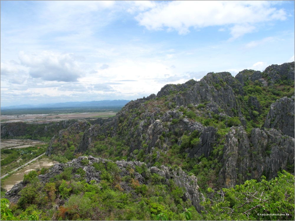
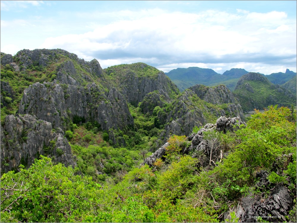
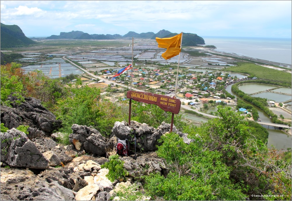
Sam Roi Yot, Bueng Bua, view northward
view northward
Sam Roi Yot, Büng Bua, view southward
view southward
Near the houses we will visit a shrimp farm.
Sam Roi Yot, Büng Bua, view eastward
view eastward, straight to the mountains
Sam Roi Yot, Bueng Bua, footbridges in the marsh
long footbridges, pavilions, here you can watch nature for hours
Sam Roi Yot, Bueng Bua, lotus flower
lonesome lotus flower. It is now early July, at this time there are only few flowers and birds.
We will come here again!
Sam Roi Yot, Bueng Bua, cormorants
Cormorants! Certainly! There are plenty of fishes.
top
red line

Shrimp Farm [2010]

shrimp farm
Shrimp farm. Many mills are necessary for ventilation.
shrimp crop
A part of the road is used as working area for sorting the shrimps.
The transporter is parking on the other side of the tent.
shrimps are sorted
Behind the house is the pond, they drain it just now
fresh shrimp
Fresh shrimp
shrimps are sorted
In the background another pond
draining of a shrimp pond
Do not forget to click the image!  
…and look at it carefully.
top
duenne blaue Trennlinie

Khao Daeng, the Red Mountain [2010]

Not more than 322 m
from the parking place to the
Khao Daeng Viewpoint? That's true!
Khun Tá, officer in the Thai army, accompanied me.

An easy task or … ?

322m to Khao Daeng Viewpoint
322 m from the parking area up to the viewpoint
[click the image!]
lizard
"Go up" the lizard said
ascent through brushwood
cactuses
… past cactuses
climbing here
… climbing on the rock. Tough, but well blazed
rest !
rest !
view of an opposite mountain

Only 322 m, but in reality steep, tough, strenuous.
From roundabout sea level up to the height of 157 m.
And with this heat!
There is not really a path, but you find where to go, because it is well marked. You climb up over limestone, through brushwood, between the blossoms of cactuses…
It is all the same, whether there are 37°C or 39°C
 
Only 322 m ?? Really ??

And now we are at the top.   Simply fantastic !

look to the W look to the NW look to the NE
Sam Roi Yot: panorama from Khao Daeng
Sam Roi Yot: panorama from Khao Daeng from W to NE

You may click on three parts of the panorama:

descent
Descent Khun Tá carries my rucksack
Khao Daeng
Khao Daeng, view from Sam Phraya Beach
Such a small hill
?!!

The descent was still more strenuous than the ascent, indeed. It was hot.
I had to rest now and then.

We reached a place, which was really steep, nearly vertical. Khun Tá did not climb, he grasped at a branch and jumped like Tarzan.
Good idea! I did so too. - Not a good idea, perhaps I am too old for playing Tarzan!

Continuing the descent. One false step… krrrrk the right ankle cracked.
The further descent was not amusing any more.

The ankle swelled, Khun Tá brought me to the military hospital in Pranburi. I got my leg in plaster. And that was the end of my holidays in Thailand.

military hospital of Pranburi
Perhaps it is better not to click on this image. Otherwise you can see, what kind of "shoes" I wore on that day.
top
red line
Valid CSS    W3C-Test